
You’ll see how Brinc’s flight features, like autonomous navigation and real-time data streaming, transform crisis response. They let you navigate obstacles safely, stream live analytics for quick decisions, and deliver supplies rapidly to affected areas. Obstacle avoidance guarantees precision in high-risk zones, while coordination tools enhance team efforts. It’s all about boosting safety and speed—explore these innovations to uncover their full impact on emergency operations.
Autonomous Navigation for Emergency Operations
As emergencies demand rapid response, Brinc’s autonomous navigation technology lets drones navigate complex environments without human input, enhancing safety and efficiency in crisis situations. You’ll appreciate how autonomous mapping creates precise, real-time layouts of disaster zones, allowing drones to chart paths independently and avoid obstacles with ease. These advanced navigation algorithms process data swiftly, adapting to dynamic conditions like debris or poor visibility, so you’re not tied to manual controls.
This freedom empowers you to focus on strategic decisions, knowing your drones operate reliably in high-stakes scenarios. By integrating autonomous mapping, you gain the ability to deploy resources faster, minimizing risks to responders. It’s about giving you control without the burden, ensuring missions succeed where every second counts. With Brinc’s tech, you’re revealing a new level of operational autonomy, tailored for emergencies where precision saves lives.
Real-Time Data Streaming in Crisis Situations
While crises unfold rapidly, Brinc’s real-time data streaming lets you access live feeds from drones, delivering essential information like video and sensor data straight to your command center. This feature integrates real-time analytics, allowing you to process incoming data on the spot for immediate insights into evolving situations. You’ll spot critical patterns, such as crowd movements or environmental hazards, without delay, giving you the edge in high-stakes moments.
Complementing this, data visualization transforms raw feeds into clear, actionable graphics—think dynamic maps and charts—that help you grasp complex scenarios at a glance. It’s about empowering you with freedom to respond swiftly and autonomously, unburdened by outdated methods. By leveraging these tools, you’re not just reacting; you’re proactively shaping outcomes, ensuring your operations remain agile and effective in the face of uncertainty. This seamless integration keeps you informed, adaptive, and in control.
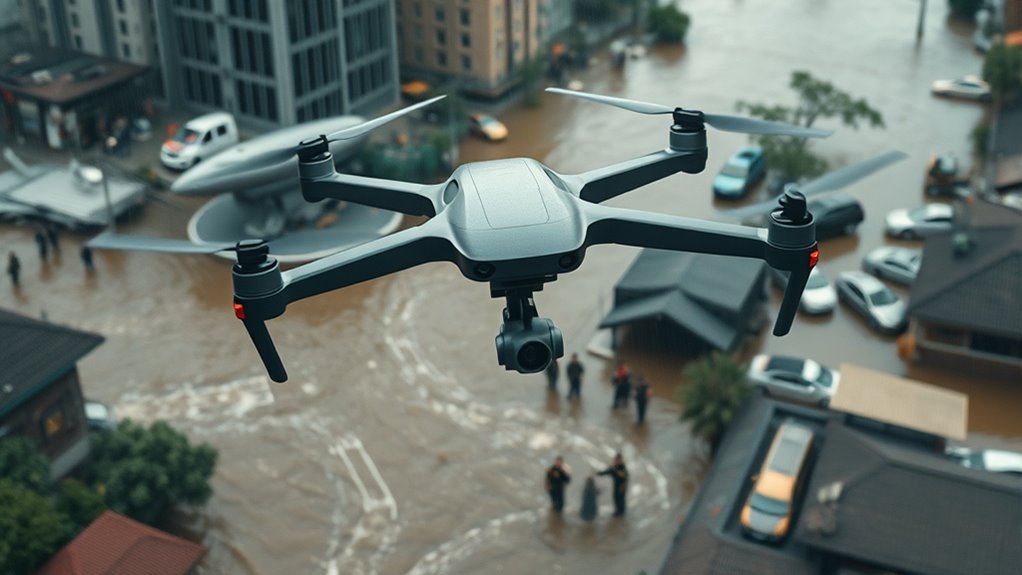
Obstacle Avoidance in High-Risk Environments
Maneuvering high-risk environments demands reliability, and Brinc’s advanced obstacle avoidance system keeps your drones safe by detecting and evading hazards in real time. This technology integrates terrain mapping to create detailed 3D models of your surroundings, allowing seamless urban traversal through crowded cityscapes filled with buildings and obstacles. You’ll appreciate how it processes data instantly, identifying potential threats like power lines or debris, so you can focus on the mission without second-guessing. By enhancing your drones’ autonomy, Brinc empowers you to operate freely in challenging areas, reducing risks and ensuring uninterrupted flights. Whether you’re traversing narrow alleys or uneven landscapes, the system’s precision sensors and algorithms adapt dynamically, giving you the freedom to respond effectively while maintaining control. This capability transforms obstacle avoidance into a reliable ally, letting you explore high-risk zones with confidence and ease.
Rapid Assessment of Disaster Zones
When you’re responding to a disaster, Brinc’s drones enable rapid deployment to reach affected areas quickly. You’ll conduct an aerial zone survey to gather real-time visuals of the terrain. This allows for instant damage analysis, helping you make informed decisions on the ground.
Rapid Drone Deployment
In crisis scenarios, Brinc’s drones can deploy in under five minutes, swiftly evaluating disaster zones to deliver critical real-time data. You gain unmatched drone efficiency, enabling seamless integration into your emergency logistics operations. This rapid deployment lets you assess threats without delays, empowering you to respond effectively and maintain control in high-stakes situations. By streamlining data collection, Brinc’s technology enhances your freedom to allocate resources wisely, minimizing risks and maximizing impact. You’ll appreciate how this efficiency transforms chaotic environments into manageable ones, where quick decisions save lives and preserve autonomy. Ultimately, it’s about giving you the tools to act swiftly, ensuring that emergency logistics align with your need for rapid, reliable solutions.
Aerial Zone Survey
Brinc’s drones excel at aerial zone surveys, rapidly evaluating disaster areas to deliver precise, real-time insights. With advanced aerial photography, you’ll capture detailed visuals of vast zones, helping you quickly identify key features and layouts from above. This empowers you to conduct thorough environmental monitoring, tracking changes in air quality, terrain, and potential hazards without endangering your team. You’re free to assess remote or inaccessible areas efficiently, gaining the autonomy to respond on your terms. As crises unfold, these capabilities let you prioritize resources based on up-to-the-minute data, ensuring your efforts are proactive and well-informed. By integrating aerial photography and environmental monitoring seamlessly, Brinc’s technology puts control in your hands, fostering independent decision-making in high-stakes scenarios. This approach streamlines your operations, allowing you to navigate challenges with confidence and speed.
Instant Damage Analysis
Through rapid damage analysis, you’ll swiftly evaluate disaster zones using Brinc’s drones, pinpointing structural failures and hazards with high-resolution imagery for immediate insights. In damage assessment, you’ll leverage real-time data to conduct precise crisis evaluation, identifying unsafe areas and prioritizing rescue efforts without delay. This capability empowers you to respond autonomously, cutting through bureaucratic hurdles and giving you the freedom to act decisively. By integrating advanced sensors, you’ll assess extensive areas efficiently, reducing exposure to dangers and enhancing overall situational awareness. Ultimately, Brinc’s tools guarantee you’re equipped for effective crisis evaluation, turning raw data into actionable intelligence that supports rapid, life-saving decisions in chaotic environments.
Supply Delivery via Drone Technology
Drones play a pivotal role in supply delivery during crises, enabling rapid and precise transport of essential goods to hard-to-reach areas. You’ll appreciate how Brinc’s advanced drone logistics streamline the process, ensuring emergency supplies like medical kits and food reach you faster than traditional methods. In chaotic scenarios, such as natural disasters, you can rely on these drones to navigate obstacles autonomously, minimizing delays and human risk. This technology empowers you by granting immediate access to crucial resources, fostering independence in isolated communities. For instance, during floods or earthquakes, drone logistics optimize routes for efficient delivery, allowing you to focus on recovery rather than logistics. By integrating real-time data, Brinc’s systems adapt to changing conditions, guaranteeing that emergency supplies arrive exactly where and when you need them most. Ultimately, this innovation enhances your freedom to respond effectively, turning challenges into manageable opportunities.
Precision Search and Rescue Missions
You’re about to see how Brinc’s drones enhance precision search and rescue missions with their accurate navigation systems. These features allow you to pinpoint locations quickly using advanced target acquisition technology. As a result, you’ll respond more effectively to emergencies, saving critical time and resources.
Precise Drone Navigation
In crisis response scenarios, Brinc’s drones leverage advanced navigation systems to enhance precision during search and rescue missions, guaranteeing operators can pinpoint targets with minimal error. You’ll experience greater control as GPS technology delivers accurate drone positioning, while flight algorithms optimize your flight paths for seamless aerial navigation. This setup empowers you to operate freely in chaotic environments, relying on real-time tracking and sensor integration for superior mapping accuracy and precision landing.
To maximize your effectiveness, consider these key features:
- GPS technology and real-time tracking: Provides pinpoint drone positioning, allowing you to monitor missions dynamically and respond instantly.
- Flight algorithms and flight path optimization: Guarantees efficient aerial navigation, helping you avoid obstacles and reach areas quickly.
- Sensor integration and navigation systems: Enhances mapping accuracy and enables precision landing, giving you the autonomy to execute rescues with confidence.
Advanced Target Acquisition
Advanced target acquisition systems in Brinc’s drones enable you to identify and lock onto subjects swiftly during precision search and rescue missions. Through precise target identification, you’ll pinpoint individuals in complex scenarios, thanks to seamless sensor integration that combines thermal imaging, radar, and AI analytics. This empowers you to operate autonomously, free from operational constraints, as the system processes data in real-time for accurate decisions. You’re no longer hindered by poor visibility or vast areas; instead, it gives you the liberty to focus on saving lives efficiently. By enhancing your response capabilities, Brinc’s technology guarantees every mission maximizes freedom and effectiveness, turning challenges into actionable opportunities with minimal risk.
Enhancing Accuracy in Field Operations
As field operations in crisis response demand precision, Brinc’s drone technology enhances accuracy by integrating advanced sensors and real-time data analytics, ensuring you’re equipped to make informed decisions swiftly. This boosts data accuracy, letting you capture reliable details amid chaos, while improving operational efficiency to keep you agile and responsive.
To leverage these features effectively:
- Achieve pinpoint data accuracy: Brinc’s sensors deliver high-resolution imagery and metrics, empowering you to assess situations without guesswork, freeing your operations from uncertainty.
- Optimize real-time analytics: Instantly process field data for clearer insights, enhancing your operational efficiency and allowing swift, independent actions.
- Minimize response errors: Automated corrections refine accuracy on the fly, so you’re always in control, maintaining freedom in dynamic environments.
Streamlining Coordination for First Responders
Streamlining coordination is essential for first responders, and Brinc’s drones facilitate this by offering integrated communication platforms that enable real-time information sharing. You’ll find that these drones enhance your operations through collaborative communication, allowing teams to exchange critical data seamlessly and build a unified response strategy. This means you can quickly synchronize efforts across agencies, reducing delays in high-stakes scenarios.
When it comes to resource allocation, Brinc’s technology empowers you to optimize deployments based on live feeds and analytics. You allocate personnel and equipment more effectively, ensuring that every asset is used where it matters most. By integrating these tools, you maintain the freedom to act decisively, without bureaucratic hurdles holding you back. This approach not only boosts efficiency but also upholds your autonomy in crisis management, fostering a more agile and responsive environment. (148 words)
Innovative Applications in Life-Saving Efforts
In crisis situations, Brinc’s drones deliver cutting-edge solutions that can swiftly locate and assist those in peril. You gain freedom to act decisively, boosting community engagement by involving locals in drone-assisted searches, while technological collaboration with experts refines real-time data for faster rescues.
To maximize these innovations, consider how you can integrate them into your response strategies:
- Enhance community engagement: You rally neighbors and volunteers to monitor drone feeds, empowering collective efforts that save lives during disasters.
- Foster technological collaboration: You partner with tech firms to customize drone algorithms, ensuring seamless integration with emergency systems for precise interventions.
- Accelerate life-saving operations: You deploy drones for rapid medical deliveries, turning critical moments into opportunities for survival and autonomy in high-stakes scenarios.
Frequently Asked Questions
What Is Brinc’s Company History?
You’re exploring Brinc’s company history, which centers on Brinc technology and its mission to empower you with innovative drone solutions for safety and freedom. Founded in 2017 by Blake Resnick, Brinc started as a startup revolutionizing emergency response. They’ve grown by developing user-friendly drones that enhance autonomy, integrating AI for rapid, reliable interventions. This evolution underscores their commitment to accessible tech that lets you respond swiftly and independently.
How Much Do Brinc Drones Cost?
You’re wondering how much Brinc drones cost, and that’s a smart question when you’re exploring drone pricing. Brinc’s models typically range from $500 to $2,000, depending on features like advanced sensors. In market comparisons, they’re competitively priced against DJI or Parrot options, offering great value for crisis response or personal use. This lets you choose freely, empowering your decisions without breaking the bank. Stay informed!
What Maintenance Is Needed for Drones?
You might think your drone’s ready for endless adventures without lifting a finger, but oh, the irony—freedom crashes when you skip drone upkeep! You’ll need to follow strict maintenance schedules: regularly check batteries, inspect propellers, clean sensors, and update software to keep it flying safely. This precise routine guarantees reliability, letting you soar with true independence and avoid unexpected downfalls. Stay vigilant!
Are Brinc Drones FAA Certified?
You’re wondering if Brinc drones are FAA certified, which is essential under FAA regulations for drone certification. These rules guarantee you’re operating safely and legally, granting the freedom to explore aerial innovations without unnecessary restrictions. Yes, Brinc drones meet FAA standards, empowering you to fly confidently in compliant scenarios, enhancing your autonomy in various applications while adhering to guidelines. Stay informed for updates.
How Long Is Operator Training Required?
Just as charting a course through uncharted skies demands precision, you’ll navigate operator certification with ease. When it comes to training duration for drone operations, it’s typically 8 to 16 hours, depending on your experience level. This streamlined process equips you with the skills to fly freely and safely, empowering your independence in the skies while meeting certification standards. Stay informed and soar confidently.
